 Skip to content

The best uses of 3D laser scanning in construction include capturing highly accurate site data for as-built documentation, pre-construction planning, and renovation projects. It enables faster, safer, and more precise measurements of existing structures, supports scan-to-BIM workflows, improves construction coordination, and helps detect errors early, reducing rework and project costs. It’s essential for quality control, facility management, and ensuring seamless integration of future building additions.
Why 3D Laser Scanning Is a Game Changer in Construction
Let’s face it, construction is complex. Mistakes cost money, delays eat into profits, and missing measurements can derail an entire build. 3D laser scanning is a total game-changer for the modern construction business.
At CooperCivil, we’ve seen firsthand how the shift to laser scanning in construction is helping project teams deliver smarter, faster, and with far more precision. No more manual measurements or relying on outdated blueprints. 3D laser scanning gives construction teams a precise understanding of site conditions from the start, reducing errors and helping projects stay on schedule and on budget,” said Tandoi Asphalt Paving & Sealcoating. With laser scanners, you can scan the entire building or construction site, capture millions of data points in minutes, and turn that information into detailed digital representations that serve every stakeholder, from architects and engineers to facility managers and project managers.
The power of a 3D laser is its ability to gather high-resolution data that not only reflects the current state of the structure but also supports the entire construction project’s lifecycle. Laser scanning benefits each phase;from architectural and engineering planning, through construction and quality assurance, to post-construction and handover by ensuring precision and efficiency throughout the project duration.
In this blog, we’ll break down the most impactful and technical uses of laser scanning technology in construction. Whether you’re working on future building additions, renovation projects, or just want more control over your project costs and construction process, this guide will show you how to maximize your return on investment.
What Is 3D Laser Scanning?
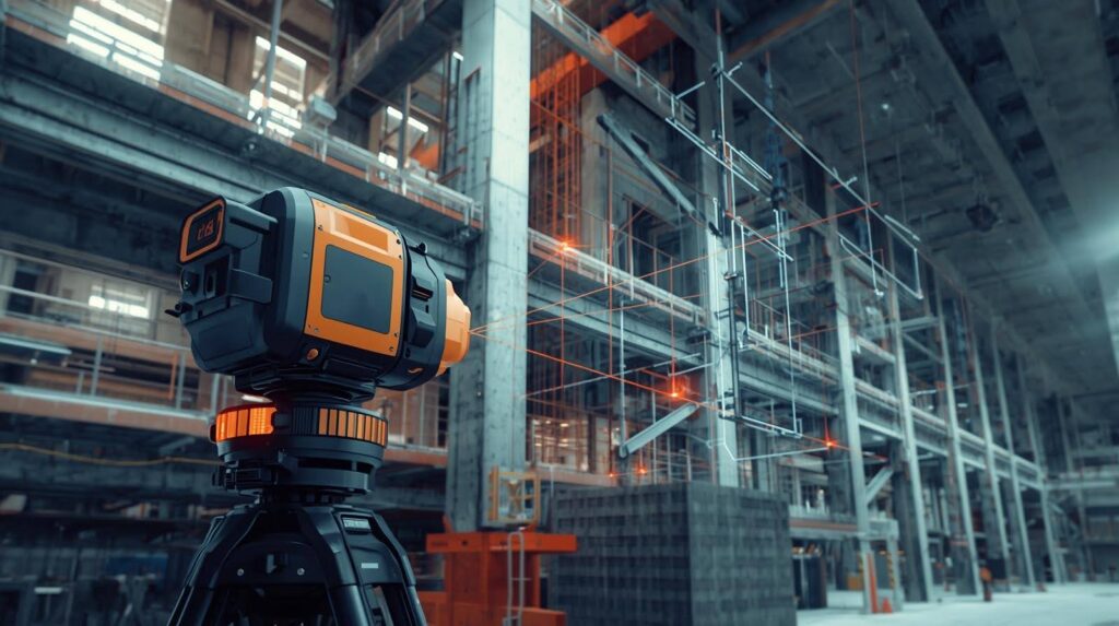
3D laser scanning is a method of collecting highly accurate spatial data from the physical environment using specialized laser scanners. These devices emit laser beams that bounce off surfaces, capturing precise distances to form a 3D model. This results in a point cloud,a digital version of the scanned environment with millions of data points.
Unlike traditional measurement methods, which are time-consuming and prone to human error, laser scanning is quick, repeatable, and precise. The point cloud data captured can be converted into models used in CAD or BIM (Building Information Modeling), making it incredibly valuable during all construction phases.
What makes this technology so powerful in construction is its ability to document existing structures with unmatched detail. Need as-built documentation of a structure with complex geometries? 3D scanning gets it done in hours instead of days.
Here’s what it typically involves:
- Setting up the laser scanner at the project site
- Capturing multiple scans from different angles
- Merging scans into one comprehensive point cloud
- Processing the data for use in 3D modeling, analysis, and planning
This technology is now standard across many areas,from design plans to construction coordination and is increasingly being adopted across the construction industry to enhance decision-making, reduce waste, and increase productivity.
How 3D Laser Scanners Work
At the heart of 3D laser scanning is LiDAR technology, short for Light Detection and Ranging. This process uses laser light to accurately measure distances to surfaces, which are then used to create a virtual 3D model of the scanned area.
Here’s how the scanning process works in construction:
- A laser scanner is placed at strategic points around a construction site or building.
- It emits thousands of laser beams per second.
- These beams hit objects and reflect back to the scanner.
- The time it takes for the beam to return is measured, providing a precise distance.
- Each point is recorded as an x, y, z coordinate;collectively forming the point cloud.
The result? A highly accurate, data-rich 3D visualization of your site or structure. And unlike photographs or sketches, point clouds contain measurable data,right down to the millimeter.
Even in difficult conditions like poor lighting, tight spaces, or unsafe areas, 3D scanners can capture full spatial data without putting workers at risk. Once the data is captured, it’s processed into a usable format, such as CAD drawings or BIM models, which can then be used for design validation, construction coordination, or structural analysis.
3D Laser Scanning vs Traditional Construction Methods
When you compare 3D laser scanning to traditional methods of surveying and measurement in construction, the advantages are night and day.
Traditional methods typically rely on tape measures, total stations, manual sketches, and even outdated blueprints. These approaches are not only time-consuming but are also vulnerable to human error. A single miscalculation can result in costly construction errors, project delays, and significant rework during the construction phase.
Now, let’s look at how laser scanning in construction turns that on its head:
It’s the new benchmark for accuracy, safety, and speed.
Firms looking to stay competitive should start implementing laser scanning by planning their adoption, budgeting for equipment and training, and integrating the technology into their existing workflows. Taking these initial steps ensures a smooth and successful transition to advanced laser scanning solutions.
Speed & Efficiency
A laser scanner can capture an entire building or project site in just a few hours. Compare that to days or even weeks of manual measuring and drafting.
Accuracy
3D laser scanners offer precise measurements down to millimeters. This level of high accuracy ensures that any downstream models or documents derived from the scans are as close to reality as possible.
Safety
In hazardous or hard-to-reach areas, laser scanning allows for data collection without putting crews at risk. There’s no need to climb scaffolding or enter unstable structures.
Data-Rich Output
The resulting point cloud contains a vast amount of spatial data, including detailed info on structural elements, geometry, and surface conditions. This is far beyond what traditional 2D drawings or photos can provide.
Time Savings
Scanning drastically reduces the time required for construction documentation, planning, and reality capture. It also enables construction professionals to make fast, informed decisions with confidence.
Simply put, implementing laser scanning is no longer optional for forward-thinking construction firms. It’s the new benchmark for accuracy, safety, and speed.
Use of 3D Laser Scanning in Pre-Construction Planning
Pre-construction planning is where 3D laser scanning can make a massive impact. Before the first shovel hits the ground, capturing existing conditions with laser scanning equipment allows project teams to work with a complete digital replica of the existing structure or site. To better understand site conditions, pre-construction teams often supplement laser scanning with GPR surveys to identify underground utilities, voids, and structural elements before design and excavation begin.
This is particularly useful for:
- Renovation projects
- Future building additions
- Working with historical buildings
- Merging new designs with older layouts
Once the data collected is processed into a usable point cloud, it can be imported into modeling software such as Revit, AutoCAD, or Navisworks. Designers and architects can then create models that are perfectly aligned with the actual conditions of the site.
Here’s how this improves pre-construction efforts:
- Fewer surprises: Hidden pipes, uneven floors, or misaligned walls become obvious before construction starts.
- Better design: New elements can be planned with pinpoint precision around what already exists.
- Tighter coordination: Engineers, designers, and construction managers can all work from the same accurate, up-to-date model.
Moreover, early access to detailed data enables better resource allocation, reduces wasted materials, and shortens the construction timeline.
High-Definition Surveying for Existing Structures
High-definition surveying (HDS) is one of the most practical applications of laser scanning technology in the construction world. Especially when dealing with existing buildings, HDS delivers accurate as-built documentation that far exceeds what’s possible through manual methods.
Let’s say you’re working on a renovation project for a decades-old facility. The original blueprints? Likely outdated, or worse, missing. That’s where HDS steps in.
Here’s what it does:
- Captures the entire geometry of the structure
- Identifies any deviations, wear, or degradation in structural elements
- Assesses the structural integrity of the building by pinpointing weaknesses or areas needing attention
- Converts raw scan data into 3D models or 2D plans for engineers to work with
This is especially important in sectors like:
- Healthcare (for upgrades and expansions)
- Industrial (for process optimization)
- Institutional (like universities and government buildings)
The result is a permanent as-built record that supports not only the current build but also future reference, maintenance, or expansion. For facility managers, this becomes an invaluable asset.
And because it’s based on millimeter-accurate measurements, teams can trust that what they see in the digital model matches what exists in the real world, eliminating the guesswork from decision-making.
Laser Scanning in Renovation Projects
Renovation projects come with their own set of challenges, tight timelines, unknown site conditions, and outdated documentation. 3D laser scanning provides detailed digital representations of the existing site, allowing construction professionals to detect and solve potential problems long before they become real-world issues.
When working with an existing structure, especially one that’s aged or altered over the years, relying on old blueprints is risky. They may not reflect the current state of the building, leading to serious issues during demolition or redesign.
With laser scanning, you can:
- Conduct a full site scan to capture the true conditions
- Identify out-of-plumb walls, floor deviations, or structural damage
- Map out utility lines and mechanical systems
- Create point cloud models that inform design and coordination
Whether it’s a minor office refresh or a full-scale retrofit, laser scanning reduces uncertainty, minimizes risk, and ensures better project execution. The ability to overlay new plans on top of the actual scanned structure allows teams to detect clashes early on, saving thousands in rework and helping maintain project timelines.
Accurate As Built Documentation
Traditionally, this process was manual, tedious, and often error-prone.
Using 3D laser scanning, you can produce a highly accurate, high-resolution as-built model that captures every detail of the built environment. This is vital for:
- Future renovations
- Facility management
- Safety inspections
- Legal documentation
The data points collected through scanning provide a full 3D map of the building, from floor to ceiling, wall to wall, capturing even the smallest deviations from the original plans. These models can be archived as a permanent as built record for years, reducing ambiguity and future confusion.
For facility managers, having this level of detail makes operations and maintenance far more efficient. Instead of relying on assumptions, they work with real data which include pipes, ducts, electrical lines, everything exactly where it is.
In short, laser scanning in construction is changing the game for accurate as built documentation, turning a traditionally error-prone process into a precise science.
Reality Capture and Site Conditions
This process provides a highly detailed, real-time look at what’s happening on the ground, eliminating guesswork and assumptions. Whether it’s an open field ready for new development or a congested mechanical room in a hospital, laser scanning captures the true state of the construction site in three dimensions.
Here’s what makes this powerful:
- Captures the entire site in hours
- Data can be updated regularly to track progress
- Enables better planning, staging, and coordination
- Detects discrepancies between plan and reality early on
For project stakeholders, having this data means fewer surprises and faster approvals. It allows project managers to make confident decisions, keep subcontractors aligned, and eliminate the need for constant site visits.
Whether you’re laying a foundation or fitting new components into a legacy building, reality capture ensures you’re working with facts, not assumptions.
Scan to BIM: Enhancing the Design Process
The integration of scan to BIM (Building Information Modeling) is where 3D laser scanning and information modeling come together to create next-level precision and coordination.
Here’s how it works:
- The laser scanner captures the physical site.
- A point cloud is generated from the scan.
- That point cloud is imported into BIM software.
- A 3D model is created from the data.
The resulting BIM model reflects the exact measurements and geometry of the construction site, helping architects and engineers avoid design clashes, optimize layouts, and plan smarter.
For example:
- MEP systems can be placed without conflicts.
- Structural designs can be refined based on real-world constraints.
- Material ordering becomes more accurate.
The scan to BIM method is essential for construction coordination, ensuring every trade works from the same, accurate model. It also becomes invaluable in future projects, where additions or upgrades depend on the accuracy of the existing model.
With BIM growing as a standard in the industry, adding laser scanning into your workflow is no longer just an advantage, it’s a necessity.
Improving Construction Coordination and Workflows
Poor coordination is a top cause of delays and costly construction errors. Imagine this: a plumbing contractor arrives on site to install piping, only to find the framing is in the wrong place. Time is wasted, the schedule slips, and costs spike. Now, picture having a 3D scan of the construction site, overlaid with the BIM model that highlights every structural and mechanical element. That’s how construction laser scanning improves coordination.
Here’s how it helps:
- Aligns all stakeholders to the same digital twin
- Reduces RFIs and change orders
- Supports clash detection before installation
- Enhances quality control and compliance tracking
This is especially valuable for large teams working on complex projects. Designers, trades, engineers, and project managers, can reference a single source of truth. The result? Faster builds, fewer mistakes, and tighter integration of construction workflows.
Structural Analysis and Quality Control
In the world of construction, the smallest structural error can lead to huge consequences. Once laser scanning equipment captures the site, the resulting point cloud data can be used to analyze the integrity of structural elements such as beams, columns, walls, and floors. By comparing the scanned model to the original design plans, construction professionals can instantly identify any shifts, warping, or misalignments.
Key Benefits for Structural Analysis:
- Exact measurements of existing components
- Detection of cracks, sagging, or movement in structural elements
- Ability to compare against tolerances defined in the design model
- Validation of geometry for load-bearing assessments
Additionally, during construction, laser scans can be taken at regular intervals to ensure that work is proceeding according to plan. This process supports high accuracy validation at every stage, minimizing surprises during inspections.
For quality control, laser scans act like a super-accurate x-ray of the site. They highlight inconsistencies between what was supposed to be built and what was actually constructed. This is particularly valuable in:
- Prefabrication validation
- Curtain wall alignment
- MEP (Mechanical, Electrical, and Plumbing) system installation
- Floor flatness verification
Using high-resolution data, contractors can immediately detect and correct errors, preventing issues from snowballing into expensive fixes later. It’s about building with confidence, knowing your structure meets specifications exactly.
Reducing Project Costs and Avoiding Construction Errors
By providing a crystal-clear digital view of the site from the start, 3D laser scanning helps construction professionals make informed decisions early. This cuts down on rework, change orders, and delays, three of the biggest budget killers in the industry.
Here’s how laser scanning directly impacts your bottom line:
- Detects errors early, before construction begins
- Reduces upfront costs tied to manual labor and resurveying
- Improves quantity takeoffs and material estimates
- Reduces downtime by allowing remote collaboration and faster approvals
For example, if a laser scan detects that an existing structural wall isn’t where the plans say it is, the design can be adjusted before materials are ordered. That saves both time and money, and prevents potential costly construction errors during the build.
Contractors and project stakeholders can also use the data to run simulations, coordinate subcontractors, and optimize schedules, resulting in smoother workflows and lower overall project costs.
Data Collection and Data Processing in 3D Scanning
In a construction project, raw scan data by itself isn’t helpful until it’s translated into models, drawings, and actionable insights.
The data journey in 3D laser scanning typically follows these steps:
- Data Collection – Laser scanners capture millions of points (often hundreds of scans across a large site).
- Point Cloud Generation – All scan data is compiled into a cohesive 3D point cloud.
- Registration – Multiple scans are aligned and merged using reference points or software algorithms.
- Data Processing – Noise is filtered out, surfaces are defined, and the point cloud is cleaned.
- Conversion to CAD/BIM – The point cloud is converted into a usable file format for drafting, modeling, or simulation.
This detailed data is then used for:
- Clash detection
- Design verification
- Scheduling
- Progress tracking
- As built documentation
What makes this powerful is the depth of information. You’re not just getting surface-level data, you’re getting everything from floor elevation changes to wall warps, HVAC duct misalignments, and more.
Advanced software tools also allow construction professionals to automate part of the workflow, speeding up timelines and reducing the manual labor of drawing and modeling.
In other words, data collected through laser scanning becomes the foundation for every intelligent decision made during construction.
Detailed Digital Representations for Future Building Additions
If you plan on adding a new wing, renovating a floor, or expanding into an adjacent space, scanning your existing structure provides a precise, up-to-date model of the current conditions. This eliminates the uncertainty that often plagues future building additions.
With a high-fidelity point cloud, architects and designers can:
- Seamlessly integrate new additions into the existing geometry
- Identify and avoid spatial conflicts before construction begins
- Align new structural components with old ones precisely
This also ensures compliance with zoning, accessibility, and safety standards, since the designs will be based on reality, not outdated assumptions.
By creating a full digital twin of the building, you’re setting yourself up for smarter design, smoother execution, and reduced errors. It’s a long-term asset that can serve the construction project’s lifecycle far beyond the current build.
Permanent As Built Record for Facility Managers
Facility managers need an accurate, easy-to-access record of the building to manage operations, maintenance, and future upgrades.
By producing a permanent as built record, you ensure that every beam, pipe, and outlet is captured and archived in digital form. This allows for:
- Faster maintenance and troubleshooting
- Efficient renovations and repurposing
- Better inventory and asset management
- Improved space utilization
For large facilities like hospitals, universities, airports, and manufacturing plants, this is critical. Knowing where every utility is located reduces downtime and prevents unnecessary damage during future work.
Additionally, these records can be linked to facility management systems for a fully integrated solution. The result? Long-term operational savings, better safety compliance, and smoother transitions for new staff or service providers.
Local Demand and Implementation
In regions like Florida, where coastal development, hurricane resilience, and strict building codes demand precision and adaptability, 3D laser scanning is quickly becoming a construction necessity.
Developers and contractors across Florida are leveraging laser scanning in construction to deal with:
- Complex remodels of older coastal homes
- Commercial retrofits in tight urban environments
- Infrastructure updates for hurricane compliance
- Historical building preservation in culturally rich areas
Best Practices for 3D Laser Scanning in Construction Projects
To get the most out of 3D laser scanning in construction projects, it’s essential to follow a set of best practices that ensure high accuracy and reliable results. Start by clearly defining the project’s objectives and the level of detail required, this will guide your approach to data collection and help you select the right laser scanner and software for the job.
Next, make sure your team has the proper training and expertise to operate the laser scanning equipment and handle the data processing workflow. Investing in skilled professionals pays off in the form of more accurate scans and smoother project execution.
A robust data management plan is also crucial. Establish protocols for data storage, security, and sharing to keep sensitive project information safe and accessible to authorized stakeholders. Regular calibration and maintenance of your laser scanning equipment are vital to maintaining high accuracy and ensuring consistent performance throughout the construction project.
By adhering to these best practices, construction professionals can maximize the benefits of laser scanning in construction, streamline workflows, and deliver higher quality outcomes for every project phase.
Why Construction Professionals Should Adopt 3D Laser Scanning
3D laser scanning is a must-have tool in the modern construction professional’s toolkit. From improving construction coordination and minimizing rework to producing detailed digital representations that drive smarter decision-making, the value is undeniable.
At CooperCivil, we believe in building smarter, not just bigger. That’s why we advocate for innovative tools like laser scanning to transform how Florida and the entire construction industry approach every project phase.